 印刷
印刷
Landscape of the Middle Ages -2
Chūsonji’s Estate
The village of Honedera exhibits a prototypical mountain village landscape. It is situated in a narrow section of the Iwaigawa river valley surrounded on all sides by mountains, or which Mt. Kurikomayama (1627m) is most famous. Houses are scattered throughout this small area. The water from mountain springs and streams creates marshland around the valley at the base of the mountains, and physical evidence indicates that these marshy areas too were cultivated in medieval times; such data is rare and precious.
The cave known as Sannō Iwaya (山王窟), which is pictured in these maps, was both a landmark for Honedera and one of its most significant religious sites—Honedera’s spiritual center. Sannō, the deity to which the cave is dedicated, was imported from China to the Tendai sect headquarters at Enryakuji Temple (outside of Kyoto), and brought with Tendai to Honedera in succeeding centuries. The presence of Tendai’s tutelary deity here is also indicative of the village’s connection to Chūsonji, a Tendai temple.
Honedera became the private estate of Chūsonji, meaning that the village paid its annual taxes directly to the temple, which used that income for its own upkeep. This relationship is attested by period sources detailing the names of the villagers and their tax payments (see Illustration 3, below). I should mention that Illustrations 1 and 2 (above) are reproductions of the original illustrated maps kept at Chūsonji, and have been cleaned up for easier viewing.
Japan’s Agency for Cultural Affairs has nominated Honedera as part of Hiraizumi’s bid for World Heritage inscription. Honedera is characterized therein as an “Important Cultural Landscape,” a landscape formed through the harmonious interaction of humankind and nature, and one which must be preserved for future generations.
Landscape Depicted in the Illustrated Maps (1)
As noted a moment ago, Honedera is a small swatch of land surrounded on four sides by mountains. The river flowing through Honedera does so at the base of steep cliffs at the valley’s southern end, and cannot be used to irrigate its paddies. Initially, water for the rice paddies came from the mountain streams to the north and northwest of the valley, which explains the rather spotty paddy layout in the maps. Another source of water was a spring near the center of Illustration 1—by the Unane Shrine (宇那根社), which is surrounded by a copse of trees—that supported several smaller paddies. Though present-day Honedera has almost completely been converted to paddy land, these maps indicate that much of the land lay untouched, with paddies only here and there. Of these, a number were inundated with stream water, become muddy and boggy. Several such areas are still verifiable today.
The Honderagawa river flowing through the center of the valley (檜山川“Hiyamagawa” in Illustration 2, above) was also unsuited for irrigation in the early years. It was nothing more than a little stream itself, the kind that you could leap right over, until Honedera became the estate of Chūsonji and received an influx of technology. Small wooden boards were placed in the stream as dams, raising the water level and allowing water to be fed to paddies on both sides. This increased the total irrigated paddy area, but even so rice did not cover the majority of the valley floor. That such medieval irrigation was confined to relatively small-scale projects primarily using springs and mountain streams is substantiated by the illustrated maps.
Professor Ōishi Naomasa, now retired from Tohoku Daigakuin University, has studied Honedera’s irrigation practices. He asked local farmers where they got their water from, and when they simply answered, “Over there,” he checked what that meant—only to find three dams (A, B, and C) on the Honderagawa. On the other hand, paddy owners in the shadow of the mountains often gave the name of a mountain stream. In other words, Professor Ōishi found that very primitive paddy irrigation systems were still in use today.
He also confirmed that the source waters for irrigation were mountain streams, springs, and small rivers like the Honderagawa. Waters from the Iwaigawa are now diverted into the Honderagawa farther upstream to provide about ten times as much water as that which was available to the medieval village. This is visible in the maps. Additionally, some of the streams fed only by mountain streams are extant today.
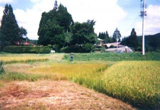 |
| [A] |
Photograph A (above) was taken in 1996. In it, you can see a student standing on the far side of the rice paddies. This is area marked as “Unane Shrine” in Illustration 1. You can also see the village’s second largest home and its rice paddies. Though they were originally dependent on the spring water here, that has more or less dried up now. Still, a little water trickles out from the same spot it did centuries ago, allowing us a glimpse of what things must have been like.
Overall, land use patterns from 700-800 years ago are well preserved, which is why homes in the valley are still dotted around much as they were centuries ago. Homes have sprung up along the National Road since it was laid down east-west through Honedera, but on the northern side of the valley at the base of the mountains the original shape of things is exceptionally well sustained, with just a few paddies around the houses.
You can also see that there are quite a lot of shrines and temples depicted in these maps. In the twelfth century, Chūsonji developed this nearby valley as an important source of tax revenue, transforming it into something like the private estates called shōen. This process of reform and metamorphosis entailed the importation of a lot of Buddhist elements, which explains the prevalence of religious structures.
Landscape Depicted in the Illustrated Maps (2)
Let’s examine Illustration 1 again. Before Honedera became associated with Chūsonji, the entrance to the village was to the east. Here you can see the characters, “Kagikake” (鎰懸). The first character is sometimes written鍵 (also pronounced “kagi”), which means “key,” but in fact the character you see here has a different meaning. 鎰 refers to an L-shape, a 90° angle or a bracket. What is significant here is that prior to the arrival of Buddhism in Japan, villages usually had a tree at their borders called the “kagikake tree” that served to as a deity to protect the villagers. Couples would throw L-shaped branches into the tree’s boughs. If the branches stuck, superstition had it that the couple would continue together happily.
There is a picture drawn by the Edo-period (1603-1868) traveler and diarist Sugae Masumi of a scene he observed near the coastal border between Akita and Aomori prefectures. In this picture, Masumi has drawn a waterfall at the village border and a tree (a “kagikake tree”) standing beside it. In the tree are numerous L-shaped objects, which turn out on close inspection to be branches like those mentioned a moment ago. And Masumi’s caption confirms the existence of this superstition, noting that couples sought to divine the future of their love by appealing to the “deity of borders and boundaries.”
What this means, then, is that the “kagikake tree” marked the border and the entrance of the village. However, you will notice both a steep cliff behind and an even more perilous one in front leading down to the river flowing below. This “entrance” would have been just sufficient for a single person to squeeze through. So when Chūsonji began to develop Honedera, the temple required a new road, which is noted on the map as the馬坂新道 (Masaka Shindō , or “Masaka New Road”). This allowed people, horses, and supplies to flow more freely in and out of Honedera, bypassing the treacherous riverside village entrance. This new “superhighway” of sorts was a critical moment in the development of the village.
Prior to that point, the village had centered on the Unane Shrine area with its spring water (see Illustration 1, above). Unane enshrined a great and fearsome water snake deity that shared its water with the faithful, allowing them to irrigate their fields. The festival of this shrine was carried out by a village leader called an obito. What is unusual about the appearance of an obito’s name in these Kamakura-period maps is that the obito are associated with ancient times and some of Japan’s earliest chronicles, the Nihon shoki and Kojiki. In any case, the obito lived in the second largest house in the village, the one by the spring. At this stage the villagers are still using just natural spring and stream water, and have yet to harvest the waters of the central river, the Honderagawa. As such, irrigated rice paddies were concentrated almost entirely at the foot of the northern mountains.
Unane Shrine was the center of the village because of its connection with the spring water, and that accounts for the presence of the obito right next door. In fact, the shrine, the spring, the ancient snake deity, and the village leader might well be thought of as a unit. Though this type of arrangement has almost completely vanished save for a few areas of Kyushu and Tohoku, the chain remains essentially unbroken even to this day in Honedera.