Two Illustrated Maps of Honedera
Two illustrated maps of Honedera (important cultural property) are preserved at Chuson-ji as precious historical records depicting the medieval Honederamura. The two maps differ in the amount of detail and hence are called the “Detailed Map” and the “Simplified Map”; in addition, they have different illustration subjects and are also known as the “Illustrated Map of Households” and the “Illustrated Map of Shrines and Temples.” Both were drawn in the late Kamakura period, but the “Illustrated Map of Shrines and Temples” is considered a little older. There are several possible reasons the maps were drawn: to be used as evidence in the Border Dispute, to ensure the control of the village by the Sutra Repository Steward, etc. In fact, it is almost certain that the maps were indeed used as evidence in the Border Dispute. On the back of the Illustrated Map of Households, there are words that translate to “for use as evidence in the border dispute between the Temple and the County.” The “Temple” refers to Chuson-ji and the “County” refers to the Kasai clan who were county stewards; it is clear that the document was submitted as evidence in the border dispute between the two parties.
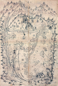
Illustrated Map of Shrines and Temples
The map is drawn on four pieces of paper joined together, with the top of the map pointing west. Research has shown that there had originally been at least two more pieces of paper at the bottom (east) of the map. The upper half of the top-right paper is missing as well.
The surrounding mountains are drawn with dynamic strokes; the village center is drawn in the middle; and the roads and the rivers are drawn as single lines. There are dotted lines around the foot of the mountains. At the western foot is written “Honedera Site,” indicating Honedera, the temple for which the village was named, was already lost then. In addition, many religious facility names can be recognized, such as Sanno, Rokusho no Miya, Kinpusan, Unane, and Worship Hall; however, Sanno and Worship Hall were added later. The map also has writings indicating that certain rice paddies belonging to religious facilities were tax-exempt; this is why the map is called the “Illustrated Map of Shrines and Temples.”
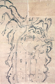
Illustrated Map of Households
The map is drawn on four pieces of paper joined together, with the top of the map pointing west; the entire village is depicted. The boundaries of the village---Kagikake in the east, Sanno no Iwaya in the west, the Iwai River in the south, and the ridgeline from Mitakeato to Masaka Shindo in the north---are represented with bold lines. This is exactly the information found in the September 10 entry of Azumakagami (1189); the map is drawn in such a way that emphasizes the boundaries of Honedera as described in Azumakagami. Another characteristic of this map is that the living space of the village is drawn in detail. The houses and rice paddies of zaike, or farmers who were obliged to pay taxes, are drawn as single units. Two types of rice paddies are depicted: those which simply use water from streams or springs, and those which have been developed through land improvements such as new irrigation systems. Regarding the religious activities of the village, the Sanno no Iwaya in the west gives a strong impression that the village as a whole was formed as a foothold for the Sanno faith of the Tendai Sect; other religious elements are the Honedera Site and Monks’ Quarter Site on the western plateau, indicated with marks representing pillar sites. As for roads, Kodo (“Old Road”) and Masaka Shindo (“New Horse Hill Road”) can be found; it appears that Kodo, located along a cliff by a river, was barely passable, and hence Masaka Shindo was built so that horses could pass as well.
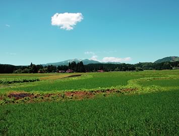
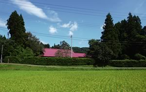
Comparison with the Landscape Today
Most of the items depicted by illustrations and words on the maps can be found in the actual landscape today. The village is truly unique in that its topography or landscape has barely changed since medieval times.
On these maps with the top pointing west, the westernmost item is “Komagatane” or “Komagata,” meaning “horse shape”. This refers to present-day Mt. Kurikoma which straddles three prefectures, Miyagi, Iwate, and Akita. When thawing begins in spring, the lingering snow forms a horse shape on the side of the mountain, hence the name.
The Iwai River, drawn on the southern edge of the maps flowing east, still flows in the southern part of the Hondera region today.
Sanno no Iwaya, drawn just below and more clearly than Komagatane on the Illustrated Map of Households, is on the western boundary of the village. To the east of it, the words “Honedera Temple Site” and “Monks’ Quarter Site” are marked with figures that appear to be pillar sites. On the Illustrated Map of Shrines and Temples “Hakusan” and “Terasaki” are written on a plateau slightly higher than the rice paddies in the western part of the village. "Rokusho no Miya" on the Illustrated Map of Households is drawn slightly apart from them, in the northern part of the plateau. Hakusan Shrine still remains in the same spot as the map, but Honedera Temple, for which the village was named, was already lost in the Kamakura period, and its site, including Monks’ Quarter, is yet to be found.
The word “Mitakeato” on the northwestern edge of the Illustrated Map of Households refers to Mitakedo, one of the boundaries of the village. This corresponds to “Kinpusen” on the Illustrated Map of Shrines and Temples. (The kanji character for Kinpusen is also pronounced “Kanenomitake.”) “Mitakeato” probably refers to “Mitakedo Site.” (“-ato” means “site.”) In the late Kamakura period when the Illustrated Map of Households was drawn, Mitakedo Temple was already lost, but the word “Mitakedo” still remains today as the mountain name, from which we can see that tradition has survived into the modern age.
Unane Shrine, drawn at the end of Masaka Shindo on the Illustrated Map of Households, is written as "Unane" on the Illustrated Map of Shrines and Temples, drawn similarly along the road. Today, there is a road named Nakamichi corresponding to the roads drawn on the maps; "Unane Shrine" and "Unane" on the maps were probably around the end of this road, which is called Unanda Mansion today. "Unane" does not mean "spring water" but rather "irrigation channel source," and Unane Shrine is dedicated to the god of irrigation. This is one of the central areas of the farming village, and drawn on the maps in the center as well.
There is a shrine depicted along Masaka Shindo which starts at Unane Shrine and stretches east on the Illustrated Map of Households; in the corresponding spot on the Illustrated Map of Shrines and Temples, there is a note "Wakamiko Shinden Nidan." It is certain that this shrine is Wakamiko Shrine. The spot is like an island in a rice paddy, higher than its surroundings, with tall cedar trees that can be seen from afar serving as a guide when walking in the rice paddies.
Near the eastern edge of the northern boundary on the Deity Map is written "Jiegara."
"Gara" means "tomb" and Jiegara is a site where the skull of Jie Daishi or Ryogen the 18th Head Abbot of the Tendai Sect is said to be buried. There still remains a cairn that is said to be the burial spot on a mountain on the village border. There is also a shrine named Jie Shrine along the national road at the foot of the mountain. It appears that Masaka Shindo ran by the shrine. On the Illustrated Map of Shrines and Temples, there is a drawing of a simple building with the words "Worship Hall"; however, it is believed that these were not included on the map in medieval times but were added later.
The above places have been designated as national historic sites and are under protection. The surrounding mountainous landscape depicted on the two maps has remained unchanged since when it was drawn. The northern mountains depicted on the Illustrated Map of Shrines and Temples are especially true to life, and the landscape on the map can still be seen from the village.
Important Cultural Landscape
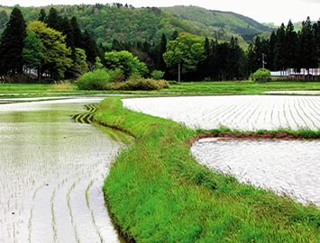
In addition to being protected as a national historic site, Honedera Shoen Iseki was designated as a national important cultural landscape in 2006, under the title "The Rural Landscape of Hondera, Ichinoseki." The 337.5-ha area is the core portion of the 761.0-ha landscape planning zone designated to protect the medieval Honederamura as defined by the four boundary landmarks and its peripheral environment. It was recognized as a unique case where a rural landscape depicted on maps from the Kamakura period remained basically the same for 7 centuries with only mild changes, while the rest of Japan underwent rapid urbanization. Small ill-shapen rice paddies and irrigation systems from medieval times have remained almost unchanged and are still in use.
Land Usage
One characteristic of the Illustrated Map of Households is that the houses and the shapes of the rice paddies are drawn in detail. Four types of rice paddies can be seen: 1) clusters of rice paddies by the houses along the mountains; 2) small rice paddies along the southern bank of the Hondera River; 3) clusters of rice paddies by the fountainhead of the Nakazawa Stream; 4) a paddy land divided into 12 rectangular rice paddies along the northern bank of the Hondera River. Paddies of types 1 and 3 use the water from the northern and western mountains, and are thought to have been developed independently by each family. Paddies of type 2 use the water from the Hondera River, but the irrigation systems are on a small scale and are thought to have been developed independently by each family.
Paddies of type 4, on the other hand, appear to have been a large-scale project with a systematic planning and labor, rather than individual efforts by the farmers. The water from the Hondera River was dammed upstream, and irrigation channels were built to draw water into the rice paddies. These were probably developed by Jizaibo Renko, who donated this village to Chuson-ji, or those with close ties to him.
But even with this development, not all of Honedera's plains became rice paddies like they are today. The names of the zaike farmers that appear in medieval documents are concentrated in the western part of the village today, implying that the abovementioned irrigation systems alone did not suffice to turn the western part of the village into rice paddies. The paddy development of the entire village did not happen until the Edo period, when the Iwai River was dammed upstream and a long channel named Sagarimatsu irrigation channel was built; after this, the rice paddies became much closer to what we see today.
But it should be remembered that rice paddies were not the sole livelihood of the farmers. As mentioned in the "Organization of Honederamura and Taxation" section, farm and mountain products such as millet, dried chestnuts, and firewood at the end of the year were paid as taxes. We can see that the lands which were not rice paddies were also fully and effectively used.
Living Space
There are several houses drawn on the Illustrated Map of Households: 1) six at the foot of the northern mountain; 2) three to the south of the Hondera River; 3) two along Masaka Shindo and Kodo. Each of them is drawn adjacent to rice paddies; this indicates that rice paddies were developed on a small scale around each house. This form of living space is still extant, with minor differences such as Masaka Shindo and Kodo having become a national road. Another characteristic is windbreaks called igune, which are planted on the west and north sides of the houses. Though it is not known whether igune existed in medieval times, they have been used in various ways in daily life: there are cemeteries and shrines inside them, and the fallen leaves are used for fuel.