Properties That Constitute Honederamura Shoen Iseki
Sanno no Iwaya Cave and Hakusan Shrine
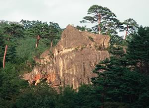 On the Illustrated Map of Households, the words "Sanno no Iwaya" can be seen on the mountain jutting out slightly west of the central area. On the Illustrated Map of Shrines and Temples, it is believed that "Sanno" was drawn on the missing part of the upper right paper; on the top part of the map, Komagatane (Mt. Kurikoma) and Mt. Sanno were probably drawn as a pair, emphasizing the significance of Sanno no Iwaya. Sanno no Iwaya is located on Mt. Sanno to the north of the Yabitsu Dam along National Road 342. Hie Sanno is the tutelary deity of the Tendai Sect and god of Mt. Hiei. The devotees of Hie Shrine helped spread Tendai Buddhism into the provinces through their commercial and money-lending activities. Sanno no Iwaya, which is dedicated to the deity Sanno, is located in an area which can be considered the inner shrine of the village; this demonstrates the important role of Sanno within the domain of Chuson-ji, a Tendai temple.
An interesting point related to this is that "Hakusan" is written next to "Honedera Temple Site" at the end of the road on the Illustrated Map of Shrines and Temples. Though the location of the Honedera Temple Site remains unknown to this day, Hakusan Shrine is still extant as a small shrine on the edge of Heisenno Plateau. "Hakusan" refers to Shirayama Hime Shrine of Kaga, present-day Ishikawa prefecture. ("Hakusan" and "Shirayama" are two different pronunciations of the same kanji characters.) In medieval times, Hakusan became a subordinate temple of Enryaku-ji, and the devotees of Hakusan and Hie together played an active role in the spread of the Sanmon school of the Tendai sect in the Hokurikudo area. It is believed that Hakusan Shrine in Honederamura, together with Hie Sanno of Sanno no Iwaya, also played a role in the spread of the Tendai sect into the region.
Both are national historic sites.
Komagatane Shrine
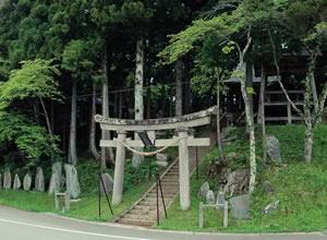 The plateau located to the west of the plains is called the Heisenno Plateau. According to “Fudoki Goyo Kakidashi,” on the Heisenno Plateau there were temples that were predecessors of Chuson-ji and Motsu-ji; however, the truth of the matter is unknown. But it is believed that places on the maps such as "Honedera Temple Site," "Monks' Quarter Site," and "Rokusho no Miya" existed on the Heisenno Plateau. Komagatane Shrine is on the jutted edge of the plateau; on the Illustrated Map of Shrines and Temples, "Bato Kannon" ("Horse-headed Bodhisattva) is located here. However, these words were added in or after the Edo period, when horse breeding became a major industry and people began to worship its guardian deity. It can be presumed that Bato Kannon became Komagatane Shrine in the first year of the Meiji period, when the Edict for Separation of Shinto and Buddhism was issued. The shrine is located on a high ground with stone steps leading up to it; the shrine commands a view of the eastern part of the village, with a rural landscape that is a legacy from medieval times. The shrine is a national historic site.
Jie Mound
 Jie Mound is a cairn located on the ridgeline along the northeastern edge of the Hondera region, which forms a boundary with the neighboring Yamaya region. According to Senjusho, a Kamakura-period collection of Buddhist tales, this was the spot where the skull of Jie Daishi, who taught the Lotus Sutra to a young woman, was buried. In the Edo period, the mound was under the supervision of Chuson-ji. At the southern foot of the mountain on which Jie Mound is located, there is a shrine called Jie Daishi built in or after the Edo period. The mound is the eastern entrance to the village from which Masaka Shindo runs, and it forms a pair with Sanno no Iwaya on the western border. It is a national historic site.
Wakamiko Shrine
 On the Illustrated Map of Shrines and Temples there is a drawing of a shrine labeled "Wakamiko Shinden Nidan." On the Illustrated Map of Households, the words are not there but the shrine which appears to be Wakamiko is drawn. It is located in the eastern part of the plain covered with rice paddies, including many small ones. The main shrine building has been lost, but an island of tall trees in a rice paddy can be seen from afar, and below them stands a small stone shrine.
According to the maps, Masaka Shindo ran north of the shrine. "Waka" and "miko" both refer to "shrine maiden"; this shrine was originally an oracle with female mediums. It is a national historic site.
Fudo no Iwaya Cave
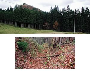
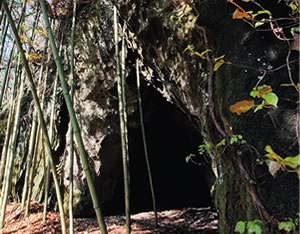 On the Illustrated Map of Shrines and Temples, you can see the words "Fudo no Iwaya" at the foot of the northeastern mountain; the cave can be found in a bamboo thicket on the northern mountainside. The cave is about 11 m deep; on the walls on both sides, you can see that there once existed doors, though the date is unknown. It is located along the road heading from Jie Mound to Kinpusen, and hence it probably was a religious facility. The cave kept its strong ties with Chuson-ji and was worshipped well into the Edo period, with a subordinate temple of Chuson-ji acting as a steward. It is a national historic site.
Mitakeato
 "Kinpusen" on the Illustrated Map of Shrines and Temples was originally a name that referred to the area stretching from Mt. Yoshino to Mt. Omine in Nara prefecture; the area is a sacred ground for the devotees of Zao Gongen, avatar of mountain worship. Zao Gongen worship was spread throughout Japan, and many mountains across the land were named "Kinpusen." In Hondera, the mountain to the northwest of "Kinpusen" on the map is still called Mitakedo. The kanji characters for "Kinpusen" can also be read "Kanenomitake," and hence the "do" or "temple" located there would naturally be called "Mitakedo." In Azumakagami, the name appears in the description of the village boundary determined by Minamoto no Yoritomo, in the phrase "from Mitakedo to Masaka in the north." On the Illustrated Map of Households, however, the spot is called "Mitakeato" instead, with marks that resemble pillar sites or cornerstones. "Ato" means "site," so "Mitakeato" probably means "Mitakedo Site." By the late Kamakura period when the maps were drawn, Mitakedo, along with Honederado, had already been lost. Today, the locals refer to the mountain itself as "Mitakedo," probably as a legacy of the lost temple. Mt. Kinpusen is also the name of the tutelary mountain of Motsu-ji in Hiraizumi, which probably was introduced into the area along with Tendai Buddhism. Mitakeato is a national historic site.
Nakazawa
 In the center of the Illustrated Map of Shrines and Temples, there are three lines labeled "Hiyama River," "road," and "Nakazawa." The "Hiyama River" is the present-day Hondera River, and the "road" is now called Nakamichi and is the main passage into the medieval Hondera. Nakazawa, on the left, is a low land between present-day National Road 342 and Nakamichi. Today, most of Nakazawa is covered with rice paddies, but at the time of the Illustrated Map of Households, only the area around the stream fountainhead was a paddy land, and the rest was only a stream. This shows the type of land where rice paddy development takes place.
Umenokida Iseki
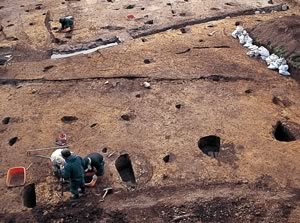 Excavation has found pillar holes 1 m in diameter on a mild slope southwest of the Mitakedo Site. The pillars are placed 2.4 m apart, which is relatively amply spaced, and from this it can be inferred that it is a site from between the end of the Heian period and the Kamakura period. On the Illustrated Map of Households, it is located near the 12 rectangular rice paddies and the impressive building that stands out. It is a national historic site.
Tonishi Iseki
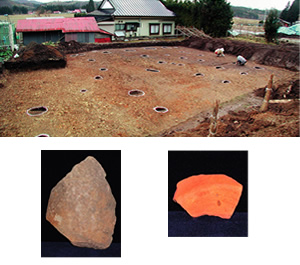 Excavation has found a piece of "kawarake" from the 12th or 13th century, and the base of a Tokonameyaki Sankinko vase. "Kawarake" are unglazed earthenware used only once in events such as parties, which are often excavated from Hiraizumi sites. Sankinko vases are earthenware from the Tokoname region of Aichi prefecture; they are often unearthed in the Hiraizumi area. They demonstrate the strong ties Honederamura had with Hiraizumi. Tonishi Iseki is a national historic site.
Yogaidate-ato (Fort Site)
 Yogaidate-ato is a small medieval mountain castle located in the center of the northern mountain, which commands a view of the entire Honederamura. Centered around the flat peak surrounded by streams to the east and west, there remain a dry moat that cuts across the ridgeline and a ring-shaped flat area. It is believed that this was built by a powerful local clan who was a subordinate of the Kasai clan during the Warring States period. At the foot of the mountain there is a Yogai Yashiki ("Fort Mansion"), which may have functioned together with Yogaidate. In the "Fudoki Goyo Kakidashi" of the Sendai fief, a person named Hondera Jurozaemon is listed, but the details are unknown. It is a national historic site.
Kagikake
On the eastern edge of the Illustrated Map of Households is written "Kagikake." The word is also mentioned as the "eastern border" in the September 10 entry of Azumakagami (1189) where the boundaries of Honedera are described. "Kagikake" is a folk tradition often found in northern Tohoku; it refers to a fortune-telling practice in which a couple throws an L-shaped twig into a large tree standing at the border of two lands. "Kagikake" can also refer to the large tree.
If the twig successfully hooks onto a branch of the tree, it was believed that the couple would tie the knot. It is thought that Kagikake has its origins in a religious rite to determine the boundaries of mountains and fields. The location of Honederamura's Kagikake cannot be determined for sure today, but it is believed to have existed somewhere along the road from Honedera to the neighboring village, via the cliff on the northern bank of the Iwai River; that was the eastern entrance to the Honederamura. This is an interesting fact which shows that a folk practice which was alive until relatively recent times in northern Tohoku can be traced back to medieval times.