 印刷
印刷
Disaster preparedness / 防災
Disaster preparedness / 防災
Evacuation sites (避難場所) and Evacuation Shelters (避難所) in Ichinoseki
[Important] Evacuation sites (hinanbasho) and evacuation shelters (hinanjo) have different purposes! Evacuation sites are places or facilities to escape to when you feel that you may be in danger. Meanwhile, evacuation shelters are for those who are unable to return home (for example, because their home has been damaged) once the danger has subsided.
[Evacuation Sites] Specified emergency evacuation areas: if you feel that your life may be in danger, these are the places to escape to first. Please make sure to check what type of disaster each location is prepared to handle (please check MyMaps and link below).
Designated evacuation shelters: The core evacuation centers in an area. These are coordinated by neighborhood evacuation centers. City officials, facility managers, and voluntary disaster prevention organizations cooperate to manage them.
These are the evacuation sites and shelters in the case of large scale emergencies ↓
Ichinoseki Evacuation Map (official)
Evacuation Map Key [1476KB pngファイル]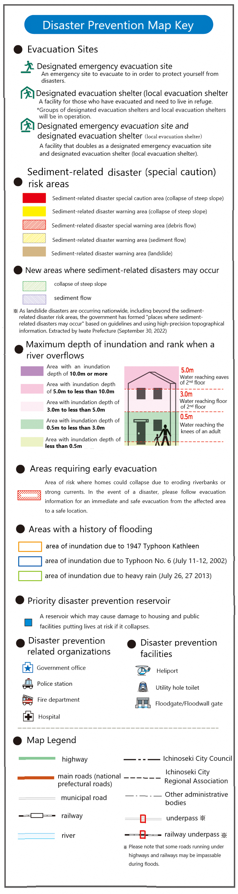
Google MyMaps of Ichinoseki Evacuation Sites (Updated April 2025)
Each evacuation site has information on what kind of disaster it is designed for either flooding, landslide (sediment) or earthquake. Please also make sure to check the most up to date information on the Ichinoseki City website, and on Ichinoseki City's official X. To check for the safest routes, use the Ichinoseki Evacuation Map (Official) linked above as a reference.
[PDF of all evacuation sites and shelters in Ichinoseki] http://www.city.ichinoseki.iwate.jp/index.cfm/30,0,64,659,html
How to get disaster information
Information on evacuations etc, is announced using outdoor loud speakers located throughout the city, ‘Ichinoseki Mail’, ‘FM ASMO(79.5MHz) Dedicated Radio (Ichinoseki Disaster Radio –You can get a free disaster radio if you are an Ichinoseki resident. This radio can only broadcast FM ASMO and has an On/Off switch. It will automatically switch on and broadcast any important information regarding a disaster –such as evacuation orders)’ and ‘Emergency Email’. However, for example, the outdoor loud speakers cannot be heard indoors when it’s windy and rainy; and emergency e-mails cannot be received on some mobile phones. ‘FM ASMO Dedicated Radio’ is the most reliable way of receiving information. (Other good resources include the City Homepage, Ichinoseki City's official X, and Ichinoseki City's Official Facebook – all resources are all in Japanese)
Ichinoseki Mail
Register for Ichinoseki Mailwhich includes
◆Information on disaster occurrence such as fire and rescue
◆Outdoor public relations ‘mast’ broadcast content
◆Crime prevention and consumer protection
◆Event information.
You can also receive information from Ichinoseki Mail onthe smartphone app @InfoCanal
Please check the city fire department headquarters homepage for details such as how to set it up.
避難場所と避難所は目的が違います。
避難場所は、命を守るために急いで逃げる場所や施設のことです。
一方、避難所は命の危険が去った後に、家が壊れるなどして帰れなくなった人が避難生活をするところです。
【避難場所等について】
指定緊急避難場所:命の危険を感じた時、最初に逃げる場所です。災害種別ごとに避難が可能か表示していますので、必ず確認したうえで避難してください。
指定避難所:地域の中核となる避難所です。近隣の地域避難所と連携しています。市の職員、施設管理者、自主防災組織など住民が協力して運営します。
地域避難所:指定避難所と連携を図りながら、施設管理者や自主防災組織など住民が協力して運営します。
【MyMapsについて】(2025年4月)
一関市の避難場所の情報がマップ化されています。
水害、土砂災害、地震などに適しているかどうかが表示されています。災害に関しての最新情報は一関市役所ホームページやXをご覧になってください。
ルート確認はIchinoseki Evacuation Map (official)をもとに行ってください。
【災害情報の確認】
避難情報は「屋外広報マスト」「FMあすも専用ラジオ(一関防災ラジオ)」「緊急速報メール」などでお知らせしています。FMあすも専用ラジオは FM あすものみを放送し、オン/オフ を設定できます。災害に関する重要な情報(避難指示など)を自動的に放送します。しかし、「屋外広報マスト」は、屋外にいる人に広報するため設備なので、雨や風の強い日は屋内にいると聞こえないことや、「緊急速報メール」は利用できない携帯電話もあるなど欠点もあります。屋内にいる時は、「FMあすも専用ラジオ」を活用しましょう。
その他の情報取得方法は市のホームページ、市公式X、市公式フェイスブック。*すべての情報は日本語です。
【いちのせきメールに登録を】
いちのせきメールでは
◆災害・救助などの災害発生情報(消防車両の出場情報)
◆屋外広報マストの放送案内
◆防犯・消費者保護
◆イベント情報など
スマートフォンアプリ「@InfoCanal」(アットインフォカナル)でも、いちのせきメールの情報を受け取れます。
設定方法など詳しくは市消防本部ホームページを確認してください。